
(An-Nur verse 43)
maksudnya, dalam bahasa melayu:
"Tidakkah kamu melihat bahawasanya Allah mengarahkan awan bergerak perlahan-lahan, kemudian Dia mengumpulkan kelompok-kelompoknya, kemudian Dia menjadikannya tebal berlapis-lapis? Selepas itu engkau melihat hujan turun dari celah-celahnya dan Allah pula menurunkan hujan batu dari langit, dari gunung-ganang (awan) yang ada padanya; lalu Dia menimpakan hujan batu itu kepada sesiapa yang dikehendakiNya, dan menjauhkannya dari sesiapa yang dikehendakiNya. Sinaran kilat yang terpancar dari awan yang demikian keadaannya, hampir-hampir menyambar dan menghilangkan pandangan. "
(An-Nur ayat 43)
• middle clouds - have bases between 7,000 and 18,000 feet. They can contain ice crystals and/or water droplets and may occasionally be associated with some light precipitation. This include altocumulus and altostratus.
• low clouds - have bases below 7,000 feet. These clouds most often composed of water droplets, but can have ice crystals in colder climates. Some of these clouds can develop into the multi-level clouds and can go through various phases, such as, a morning stratus deck turning into late morning stratocumulus, then early afternoon cumulus, and vertical development into cumulonimbus which can produce heavy rain and possible lightning and thunder.
• fog - cloud in contact with the ground. It can be considered as a low stratus cloud in contact with the ground. When the fog lifts, it usually becomes true stratus. Click this photo to see fog over the Pemigewasset River basin with clear skies elsewhere.
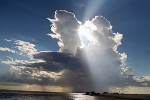
• multi-level clouds... vertically thick spanning multiple layers, the heavy precipitation producers. The depth of these clouds give precipitation hydrometeors a better environment to develop and grow. This clouds consist of nimbostratus and cumulonimbos.
• orographic clouds - distinct clouds that form via interaction between wind and mountainous terrain features are produced by the flow of air interacting with mountainous terrain. This type of clouds consists of cap clouds and lenticular clouds.

Hail
Hailstones grow two ways: by wet growth or dry growth processes. In wet growth, a tiny piece of ice is in an area where the air temperature is below freezing, but not super cold. When the tiny piece of ice collides with a supercooled drop, the water does not freeze on the ice immediately. Instead, liquid water spreads across tumbling hailstones and slowly freezes. Since the process is slow, air bubbles can escape resulting in a layer of clear ice. In other way, dry growth hailstones grow when the air temperature is well below freezing and the water droplet freezes immediately as it collides with the ice particle. The air bubbles are 'frozen' in place, leaving cloudy ice.
Hailstones can have layers like an onion if they travel up and down in an updraft, or they can have few or no layers if they are 'balanced' in an updraft. One can tell how many times a hailstone traveled to the top of the storm by counting the layers. Hailstones can begin to melt and then refreeze together, which forming large and very irregularly shaped hail.
Hail is larger than sleet, and forms only in thunderstorms. Hail formation requires air moving up (thunderstorm updraft) that keep the pieces of ice from falling. Drops of supercooled water hit the ice and freeze on it, causing it to grow. When the hailstone becomes too heavy for the updraft to keep it aloft, or it encounters downdraft air, it falls. In the other words, it falls when it becomes heavy enough to overcome the strength of the updraft and is pulled by gravity towards the earth. How it falls is dependent on what is going on inside the thunderstorm. hailstones bump into other raindrops and other hailstones inside the thunderstorm, and this bumping slows down their fall. Drag and friction also slow their fall, so it is a complicated question!
If the winds are strong enough, they can even blow hail so that it falls at an angle. This would explain why the screens on one side of a house can be shredded by hail and the rest are unharmed [5].
Subhanallah.. Humans always look at sky and clouds, but do they know the secrets behind that?
'Semakin bertambah pengetahuan manusia, maka semakin tebal pula keimanan dan keyakinan mereka bahawa Al-Quran berasal dari Allah s.w.t., dan ia benar serta tidak tersentuh kebatilan sedikitpun.' [4]
[1] Plymouth State University Meteorology Program Cloud Boutique, http://vortex.plymouth.edu/clouds.html/
[2] Cloud physics, from Wikipedia, the free encyclopedia, http://en.wikipedia.org/wiki/Cloud_physics
[3] Hail, http://en.wikipedia.org/wiki/Hail
[5] Hail Basics, http://www.nssl.noaa.gov/primer/hail/hail_basics.html


No comments:
Post a Comment